-
Member pricing
£8.99 -
Non-member pricing
£9.99
Out of stock
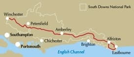
Map of the 100 mile (160km) South Downs Way National Trail, between Eastbourne and Winchester. This booklet is included with the Cicerone guidebook to the trail and shows the full route on OS 1:25,000 maps. The trail typically takes a week to walk and is suitable for most levels of ability.
Seasons
can be walked at all times of year – this is one of the driest and warmest parts of England
Centres
Winchester, Brighton, Eastbourne
Difficulty
the South Downs Way is a waymarked bridleway; very few stiles; few towns/villages en route; 12 stages (max length 12 miles)
Must See
Beachy Head, Long Man of Wilmington, Ditchling Beacon, Clayton Windmills, Butser Hill, Winchester
| Weight | 200.00 g |
|---|---|
| ISBN | 9781852846183 |
| Author of book | Kev Reynolds |
| Publisher | Cicerone |
| Publish Date | 01 May 2016 |
| Language | English |
| Page size | 116mm x 172mm |
| Binding | Paperback |
| Number of pages | 219 |


Customer reviews
There are no reviews yet.